Sanborn Geospatial Announces Expansion of EDCON-PRJ Capabilities Following Strategic Integration
The Sanborn Map Company, Inc. (“Sanborn”), a national leader in geospatial data and mapping solutions, today announced the official expansion of EDCON-PRJ’s capabilities as it becomes part of the Sanborn family of companies. This integration strengthens Sanborn’s geophysical surveying offerings, while providing EDCON-PRJ customers with expanded technical capacity from the equipment developed by Sanborn Geophysics. The move also brings EDCON-PRJ access to more markets and capabilities across Sanborn’s broader portfolio.
Sanborn’s Broadband NavigatorTM automates the BEAD Challenge Process
Sanborn’s Broadband NavigatorTM web portal technology (https://sanborn.com/broadband-navigator/) provides states a cost effective and uniform guidance compliant method to automate their BEAD Challenge Process.
Jamie Curtin joins Sanborn as Executive Vice President for Strategy and Business Development
The Sanborn Map Company, Inc. (Sanborn) is pleased to announce that Jamie Curtin has joined the Sanborn team in the role of Executive Vice President for Strategy and Business Development.
Sanborn Analysis Supports A New Approach to Mapping Poverty Nationwide
The Economic Innovation Group (EIG) has released a major report: "Advancing Economic Development in Persistent-Poverty Communities" that finds a larger base of persistent poverty across the nation than previously estimated.
Oklahoma’s New Broadband Map Will Help Guide High-Speed Internet Expansion Across the State
The Oklahoma Broadband Office, led by Executive Director Mike Sanders, has launched an interactive online map that details the availability of internet service across the state. The AppGeo Division of The Sanborn Map Company (Sanborn) worked closely with the Broadband Office to realize their vision for the application.
Sanborn hires Chris Ogier to lead its Mapping Division
The Sanborn Map Company, Inc. (Sanborn) is pleased to announce that it has hired Chris Ogier, CP, to be the Vice President and General Manager for the Mapping Division of the company.
Sanborn Joins Overture Maps Foundation to Advance Open Map Data at a Global Scale
The Sanborn Map Company, Inc. (Sanborn) announces membership in the Overture Maps Foundation as a Contributor Member. The Overture Maps Foundation is a new collaboration founded by Amazon Web Services, Meta, Microsoft, and TomTom as part of the Linux Foundation for the purpose of creating reliable, easy-to-use, and interoperable open map data for the globe.
Sanborn promotes Morgen Healy to General Manager of the AppGeo Division
The Sanborn Map Company, Inc. (Sanborn) is pleased to announce the promotion of Morgen Healy to General Manager of the AppGeo Division.
Sanborn Appoints Kate Hickey as Chief Operating Officer
The Sanborn Map Company, Inc. (Sanborn) is pleased to announce the appointment of Kate Hickey as Chief Operating Officer.
Sanborn Employee Doug Browning Wins “MVP” at ESRI UC 2023
The BLM Assessment, Inventory & Monitoring (AIM) Program Team includes members from multiple internal and external entities including The Sanborn Map Company. One individual on the AIM team, contractor Doug Browning from Sanborn, was recognized as a 2023 Top 3 ESRI Community MVP.
Sanborn, an Authority in 3D Models, pioneers the Digital Twin Base Map
Cities and counties now have a powerful new tool at their disposal with the release of the Digital Twin Base Map. Developed by leading tech firm The Sanborn Map Company (Sanborn), this innovative technology sets a new standard for urban analysis, implementation of Digital Cities, navigation, and planning with a fundamental transformation from a 2D map environment to a 3D environment.
Missouri 911 Service Board Initiates First Ever 6-Inch Resolution Statewide Imagery Program with Extensive Buy-up Options
Recognizing the importance to public safety and to many other government operations of high-quality aerial imagery, the Missouri 911 Service Board has partnered with the Department of Conservation, the Department of Natural Resources, and the Missouri GIS Advisory Council to launch a statewide imagery collection program. The imagery will be available at no charge through the Missouri Spatial Data Information Service (MSDIS).
NSGIC’s Geospatial Excellence Award Goes to AppGeo’s Michele Giorgianni for State GIS Strategic Planning
The Sanborn Map Company is pleased to announce that the National States Geographic Information Council (NSGIC) awarded Sanborn subsidiary AppGeo’s Michele Giorgianni one of its Geospatial Excellence Awards, stating that “The work that Michele has been leading is setting a new standard for GIS strategic and business planning that other states can benefit from.” Giorgianni was recognized for her role as a “Catalyst” for state GIS strategic planning, referencing the contribution that Michele has made as a Project Manager and leader on recent state GIS strategic planning projects for Montana and Indiana, as well as her contributions to many other states GIS programs.
Sanborn Acquires AppGeo; Creates Geospatial Powerhouse
The Sanborn Map Company, Inc. (Sanborn) a geospatial solution provider of analytics, imagery, lidar, photogrammetry, software applications, and related services to government and commercial clients, announced today that it has acquired Applied Geographics, Inc. (AppGeo). AppGeo has helped hundreds of governments and businesses develop the best GIS, location intelligence, and geospatial solutions for their needs. Sanborn was represented by The Environmental Financial Consulting Group, LLC (EFCG) and AppGeo was represented by Mirus Capital Advisors, Inc. Terms of the acquisition were not disclosed.
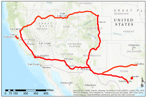
Sanborn Expands the Sanborn M-Map® Coverage for Autonomous Vehicles
The Sanborn Map Company, Inc. (Sanborn) announces today it has successfully completed the collection of geospatial data for 4,250 line miles of highway throughout the western United States, allowing the firm to appreciably expand the reach of its Sanborn M-Map® product line.
Sanborn Invests to Support Customer Demand
The Sanborn Map Company, Inc. (Sanborn) today announces the recent acquisition of additional remote sensing and data acquisition capacity and capabilities. In 2022 Sanborn has added a new Riegl Mobile Lidar system, a Teledyne Oceanscience Z-Boat® 1800-RP for hydrographic survey, additional Vexcel UltraCam Eagle digital frame cameras, and new aircraft including the purchase of a Turbo Aero Commander 695A.
Sanborn Appoints VP of Research and Development
The Sanborn Map Company, Inc. (Sanborn) announces that Dr. Baharak “Becky” Soltanian has joined the Sanborn team as Vice President of Research and Development. In this role, Dr. Soltanian will be responsible for innovating new processes, new products, and new applications based upon Artificial Intelligence (AI), Machine Learning (ML) and edge computing. Additionally, she will manage and support Sanborn’s internal software team. “Becky is the right leader for our technology development team,” says John Copple, CEO of Sanborn. “Becky’s extensive background will help Sanborn bring more value to our customers and strengthen our investment in automation. We believe her strong technical experience will help focus Sanborn’s efforts on the latest cutting-edge technologies.”
Sanborn Supports the Red River Water Management Board With Mapping Technology for Water Resource and Flood Control Needs
The Sanborn Map Company, Inc. (Sanborn) announces it has completed collection of more than 20,000 square miles of Quality Level 1 lidar for the Red River Watershed Management Board (RRWMB). Sanborn completed the lidar acquisition over a 29-day period in the fall of 2021. The data will be processed using technology that includes AI algorithms to extract ground, vegetation, hydrography, and structure information.
Sanborn Wins Major Mapping Contract with USGS
The Sanborn Map Company, Inc. (Sanborn) has been selected by the U.S. Geological Survey (USGS) for a multiple-award indefinite delivery contract with a ceiling of $850 million. The Geospatial Product and Services Contract (GPSC 4) is a successor to the GPSC 3 contract that Sanborn was previously awarded. The Geospatial Product and Services Contract allows the agency to negotiate task orders with Sanborn for the next five years.
Century Turbo Aero Commander Still Flying Strong
Recently, Hurricane Ida has devastated a significant portion of Louisiana and parts of surrounding eastern states. On August 29, 2021, aircraft N940U dispatched on an aerial survey mission out of Horn Lake, Mississippi, where Sanborn has a hanger for the plane. N940U, a 1969 Turbo II Commander 680W, responded flying another aerial survey mission in its 52-year life, as it always has. With a certificate of air worthiness issued in April of 1969, the aircraft operates daily by Sanborn of Colorado Springs, Colorado who purchased the plane in 2006.
Sanborn Supports Nassau County FL Property Appraiser With Mapping and Geospatial System Integration
The Sanborn Map Company, Inc. (Sanborn) was awarded and has successfully delivered a geospatial solution to Property Appraiser, A. Michael Hickox, Nassau County, FL, with delivery software, software integration, oblique imagery, and orthoimagery of the county.
The Sanborn Map Company, Inc. Wins Indiana Contract to Collect Statewide Digital Orthoimagery
The Sanborn Map Company, Inc. (Sanborn) is excited to announce it has been awarded a four-year contract, with the Indiana Geographic Information Office (GIO), to provide updated digital orthoimagery for the entire State of Indiana. Sanborn will acquire and process 15 cm spatial resolution, leaf-off, four-band imagery on a tiered, cyclical basis for the 36,418 square mile project area. At the writing of this press release, imagery for the first year of the program has been successfully captured.
The Sanborn Map Company, Inc. to Provide the State of Vermont with New Digital Orthoimagery
The Sanborn Map Company, Inc. (Sanborn) is pleased to announce its five-year contract with the Vermont Center of Geographic Information (VCGI) to collect state-wide digital orthoimagery. Sanborn will use its state-of-the-art fleet of aircraft and digital sensor technology to collect 30 cm spatial resolution, four-band imagery for the orthorectification mapping process.